Wednesday, September 30, 2009

Trip Archives: 2002

More from the archives and saving stuff from deletion with the demise of my Geocities site.

In 2002 our first daughter was born and I wrote a thesis. I didn't go very far that year, nor did I go very often.

Night Paddle. Late August, 2002. Several friends (Rob, Joel, Kevin, Larry?, who else?) & I did a paddle from Beaver Creek (Fred Heal Canoe Launch) back to Saskatoon on the South Saskatchewan River by the light of the full moon. There were 2 canoes and 2 kayaks, each with a glow stick on the bow and stern so that we could see where the others were in the dark. We left around dusk (9:30 pm?) and arrived back at the boathouse by about midnight. This was an excellent experience. It was a beautiful night. We were surprised by a few beavers along the way. Imagine, your gliding gently along, able to see only the faint outline passing shoreline, the only sounds the hushed "blip .... bloop" of an unhurried paddle stroke, when from less than a metre away you here a giant KAPUCH! as a beaver slaps it's tail and dives. Visibility was not normally a problem, though we did find ourselves running aground occasionally on sandbars, but that happens almost as easily in full daylight as well.


Solo Hike to Grey Owl's Cabin. Early November, 2002. Prince Albert National Park. The weather was cold with a bit of snow on the ground. I hiked this 40 km trip over 3 days, with just my dog for companionship. Leaving in the mid-afternoon, I hiked about 2/3 of the distance the first day and set up camp at Sandy Beach. Kingsmere Lake was open with a bit of ice along the shore in some areas. The second day I hiked the rest of the way to the cabin at Ajawaan Lake where I spent some time taking in the area, reading the guest book and exploring. Ajawaan was frozen solid, but I opted not to take a short-cut across the ice. I returned to camp late in the afternoon then headed back to the trailhead the next morning. Much of the time during this trip a cold breeze was blowing off the lake making it seem colder than it really was (-5C to -10C). On the return trip I cut across the ice and along the shore in the southeastern part of the lake over to the Southend campsite.


Shortly before I embarked on this trip I had something of a mishap. I was up on the roof of my one story house using a water hose to spray out the gutters while the temperatures were near or just below freezing. The ladder was set-up on the painted wood deck, which was now wet and possibly icy. Unfortunately, I didn't realize this and I stepped onto the ladder to descend. Predictably, the bottom of the ladder slid out and I came crashing down, landing on my chest. I had hollered on the way down, bringing neighbours and my wife running. Once I hit the ground, the wind was knocked out of me and I was unable to make any sound. That was a novel experience for me and thankfully I was able to breathe again after a few seconds. I got up right away, but quickly determined that remaining prone was best. An ambulance was called and the fire department was the first to show up. I was immobilized (an experience that put me at the wrong end of all that Ski Patrol training I had received), loaded into an ambulance and taken to hospital. After being checked out, it was determined that I merely had cracked or bruised ribs.

It was a few days later that I decided to head up to PANP for some hiking. I had done a day-hike the day before in the hills near Little Red River Park and found that I could hike all right and manage the pack. Sleeping on a thermarest provided some discomfort, but wasn't too bad. However, I began to develop something of a cough over the weekend out. That gave me some grief on the trip, but it wasn't until I was home that things got bad. I developed a bad case of bronchitis. Bronchitis, with cracked ribs is something I hope to NEVER experience again, nor would I wish this on my worst enemy. Every time I coughed, which was most of the night for a week or more, it was like being slammed hard in the chest with a 2x4. The doctor gave me some prescription cough medicine stating that the over-the-counter stuff is pretty much useless. The prescription stuff she gave me contained codeine which at least helped to knock me out for a while.

Tuesday, September 29, 2009

Trip Archives: 2001

Yahoo Geocities is shutting down in less than a month and my site there will be deleted. Therefore, I've got to move some of my trip reports before they are deleted. Over the coming days & weeks you'll see them show up here at pawistik.blogspot.com.


Prince Albert National Park, Fish Lake, May, 2001. Four of us (K., Mike, Laurie, Bryan) hiked into Fish Lake in the South end of PANP.


The weather was cool and it rained early in the weekend which chased everyone else away after the first night in the campground. After everyone left, the sky clear
ed and it ended up being a pretty nice weekend. If I'm not mistaken, this was our first time that we met Mike, or perhaps it was merely the first time we really got to evaluate him!


Churchill River - Stanley Mission to Nistowiak Falls. June, 2001. Easy 4 day trip. Bryan, Rob, Rod & Jay, The inaugural NorthStar Expeditions trip! We were hit by a squall just after reaching our campsite on "Camp Island". We took shelter from the hail and downpour sitting underneath a tarp draped over a large log. Camp Island is a convenient, if rather small, camp spot several kilometers from Nistowiak Falls. A few meters away was "Shit Island", which is where you had to go to take a crap since there was very little room for that on Camp Island. You won't find these neames on anybody elese's map by the way. Nistowiak Falls was amazing, I highly recommend paddling there at least once. I think this would make an excellent destination on skis too.


View Larger Map


Churchill River - Devil Lake, Barker Lake, Rapid City. July 2001. Tandem Whitewater Course, Level I (3 days). Course was offered through the Saskatoon Canoe Club and instruction was provided by Horizon's Unlimited.


View Larger Map


Kingsmere Lake, Prince Albert National Park. September 2001. K., Bryan, Laurie & Mike. We went back to PANP, canoed into Kingsmere Lake and paddled the "Bagwa route". I think this might have been the time we saw a moose in the channel between Pease Point and Bagwa Lake.


Monday, September 28, 2009

Canoe Tripper Personalities

The following is slightly edited and taken from http://www.adventures.wildrec.net/general_info/The Canoe Tripper.htm. I can see myself, for better or worse, in some of these folks. I also see aspects of the people I trip with in the list.


The Canoe Tripper
Which describes you on a trip?

Flatulent Fred: Who gasses out the start of a portage with a massive release caused by a Harvest Foodworks curry dish. I mean, we’re outside… how can anyone be that toxic?

Tipsy McSwagger: who can’t manage more than an inch of water in the cook pot from tips and spills on the way back to the campsite from the shore.

Lord of the Manor Lyle: Whose tent is so big you feel like a tenant farmer in yours. And he still manages to drape, prop and dump his equipment all over the site!

Day One Dan: Who does his carefully calculated share of the chores in the first day and then waits and watches as others catch up.

Hypochondriac Harry: Every scratch turned into gangrene; every noise in the dark a bear with rabies. He boiled his water for half an hour to kill bacteria and parasites, but still had giardia cramps the entire trip.

Whining Wilbert: "Aren't we there YET" ..."how much longer", " this canoe is too tippy and its too slow" "you keep leaving me behind".

Fashion Show Freddie: Who has all the best and most expensive gear and just loves to talk all about all his shiny new stuff, while pointing out whats wrong with my old canoe and assortment of other battered and bruised items. Sometimes seen on a portage, snickering as I struggle past. Oddly enough, every year I overtake Freddy on the portage while he fiddles and adjusts things to make it easier(?) to portage.

Floral Flora: Scared of the dark and / or bush. Leaves the perimeter of campsites littered with white 'flowers' and other undesirable offerings even when there is a perfectly good thunder box just down the trail.

Clean Carl: Has to shave and have a bath daily. Not a bad thing but rinsing all his soap off in the water immediately in front of camp is.

Mr. Type A: Always trying to organize the perfect trip.

Garbage Bag George: Who packs "all" his gear in thin cheap plastic bags.

Bugged out Betty: Freaks at any insects around and constantly whines about bites...like we all need to be reminded that we are getting eaten alive!

Where did it go Willie: the guy who can never find his mug or flashlight (that he just had in his hand) or his TP or his plate etc. And he can't find them cause he just leaves all his stuff lying around and then forgets where he left it or it is dark. Of course...he borrows yours and them loses it!

Burn-it-all Bob: This is the guy who loves a raging fire and towards the end of the evening throws on ALL the wood you scavenged so there is not so much as a stick left for the morning fire.

Phantom-Paddle Phil: Whose stroke rate matches yours, but as for water displaced, it consisted of placing the blade in the water and allowing the forward motion of the boat to move the blade towards the stern.

Tip-it-in Tim: Who has to launch boulders/logs/ rocks down the edge of whatever cliff you are sitting on, so that all the wildlife within a 40 km radius is silent or gone by the time the echoes die down.

Early-Morning Earl: Who has to rattle around in the pots etc while it is still dark outside so he can have that morning java ready before its really morning.

Loud-Laugh Lenny: Who is always in the next site across the lake, and who can't discuss any topic without braying his irritating laugh like a donkey so that everyone on the lake can hear.

Cagey Camper: Who knows the duty roster off by heart. They can tell you who did what on which day - back five days and forward six. But the odd thing is - it's never their turn to do anything, it’s always somebody else’s.

Beer bottle Bob: He really likes beer, you meet him on the portage trying to make it across with 24 beers in the bottom of a sleeping bag slung over his shoulder, only to find there’s no way to keep it cold, then wishing he was British before giving up.

Gear Junky Jim: Always has the nicest and latest gear, but has absolutely no experience or know-how to use it! But he always looks good in photos.

Coffee Cal: Has to make his coffee as soon as he gets into camp. Makes only enough for him, and then of course has to drink and savour it real slooooooowwwwwwww, while camp is being set up and dinner is being made. Of course he never notices, even when told directly.

Buck Naked Ned: Alienates all other trippers on the route by being au natural as much as possible. Blissfully unaware of double entendres when asking other parties to join yours for a lunch. "Want some sausage and bagels?" He says while wearing nothing but a hat?

Raging Ronny: Totally out of control when they get mad; throwing packs and gear around on the portage and then later wondering "Gee this pot has a big dent in it. I wonder how that happened?"

Sour Puss Paul: If the slightest thing doesn't go their way...the rest of the trip is ruined...for everyone.

Fisherman Freddie: The one who does nothing around camp but has time to fish from dawn to dusk.

Lippy Louie: The one who keeps talking even when there is wildlife to view, never shuts up when relaxing by the fire.

Snag Boy Bobber: The one who is always decorating the surrounding trees for Christmas with his lures.

Photography Pete: We all love pictures, but photography Pete brings SLR + backup, 30 lbs of lenses and accessories, and will be busy getting a picture of a yellow billed Canadian prairie chicken instead of paddling.

Tired Tom: You've made breakfast and packed everything but the tent and his sleeping bag by the time he rolls out at 10am. See also Al Khaholic and Lonnie the Lolligagger. I may fall into this category occasionally. It is vacation after all!

Al Khaholic: Makes a habit of imbibing a little to much, and all your meals to/from the put in have to be at liquor serving establishments.

Forgetful Fred: You're bringing the stove, right Fred? You end up cooking over campfires. You always bring the really important items when going with this person.

Lonnie the Lolligagger: You tell Lonnie to meet at your house at 10:00 to leave. You tell everyone else 10:30, and he's still the last one to roll in.

Charlie Cheapskate: You get this, and we'll settle up later, right? Or, Well yeah you drove, gassed up and its your canoe, but I bought Tim Horton's on the way up! You think back to him grimacing when you got a large coffee instead of a medium.

Experienced Eric: 2 different types - Offers unwanted/unwarranted advice, and dumping or grounding is always your fault. "you should use a modified semi-J stroke and we would have cleared that hidden rock", OR "yeah I have paddled blah blah". Runs you up against a rock in class 1, and then dumps you with a perfect upstream lean.

Toilet Ted: The one who has to go to the washroom when you look his way to help with any chore.

Starvin Marvin: Checks the food barrel with increasing frequency as the trip progresses and becomes increasingly aware of (your!) portion size with each passing meal.

Boris Boolsheet: The guy who comes on the trip based solely on his professed years of backcountry experience and expertise. Only too late will you discover that his years of backcountry experience all took place 30 years ago in camp Sog-Ghee-Can-Vas, and that he is expert only in exaggeration.

Mal Lodgement: Mal tires quickly and wants to stop at the first place that he deems a “good place to camp” – this could be a dank, swamp-like bog area with no dry ground, mosquito hell or the side of a steep, rocky hill. Mal wouldn’t recognize a good campsite if one bit him in the arse, and the idea of paddling around the next bend or point to see if there is something better is anathema, Mal will go no further.

Talkative Tessie: has never heard a bird sing, the breeze in the treetops or a distant loon call. Mostly because Tessie has never stopped talking. Tessie can spend 45 minutes blathering on and on about some minutia in her life – a brake job on her car, her redecoration plans, her annoying coworkers (just imagine how they feel). The urge to whack Tessie in the head with your paddle is almost overwhelming.

Hopeful Hank: "Let's just go a little further, their could be a better site ahead" he says as you pass a site with sandy beach, flowing well, just enough onshore breeze to keep bugs down, & firewood the previous tenants left. You end up spending the night in a bug filled swamp on the only piece of land six inches above the water table for miles.

Tippling Tim: Has to stop at every Tim Horton's on the way to the put in, and after you take out, always looking for that last perfect cup of coffee. The only problem is, 30 minutes later he has to pee again, and therefore demands another Tim’s. After he empties, of course he fills up again!

Battling Bob: everyone is packed up and ready to go, and he has to clean out and sort his wallet, empty his entire pack looking for a safety pin, etc. It is a battle to get him on the water at any time, when everyone else is ready!

Gus Gottagetback: Says he can make the 3 day trip but then when he shows up he mentions about and hour into the trip that he has to be back early the last day forcing the rest of the trip to be rushed.

Phil Foodsucks: The guy that looks at the food you've prepared, packed and cooked for the large group and complains. Of course the same guy doesn't offer to carry anything other than his paddle, thermarest and sleeping bag on the portage, doesn't offer to help cook or do dishes.

Soggy Sam: The guy with the tent that leaks and inadequate rain gear. This wouldn't seem as bad if he hadn't shown up on the last trip with the same collection of cheap, crappy or poorly maintained gear. Usually found in camp holding a pair of charred socks (his only pair) over the fire on a stick.

Ted Trustfund: Ted has the best of everything. Carbon fiber-kevlar canoe, graphite paddle, four-season tent that cost more than my car.

Update: I found the source of the list on the myccr.com forums. It was written by a group of forum participants folks several years ago. It's an 8 page thread so read through it and see how the conversation went!

Thursday, September 17, 2009

Steve Earle at the 2009 Ottawa Bluesfest · CBC Radio 2

Steve Earle at the 2009 Ottawa Bluesfest · CBC Radio 2 - Concerts On Demand

I'm finally getting around to listening to this concert that first aired on CBC Radio 2 earlier in the summer. Like most everything I've ever heard from Steve Earle, it's fantastic. In this concert he plays a healthy selection of Townes Van Zandt songs, no surprise at any Steve Earle concert, but even less so since he recently released the album "Townes".
"Townes used to say that there's two kinds of music, there's the blues, and there's zippity do dah. And this aint zippity do dah."

Shared via AddThis

Tuesday, September 15, 2009

A lifetime of paddling adventures


A lifetime of paddling adventures - Winnipeg Free Press

Don Starkell, author of Paddle to the Amazon and Paddle to the Arctic, and a prominent figure in the books Kabloona in the Yellow Kayak and Journals of the New Voyageurs, claims to be a few kilometers away from having paddled the equivalent of three times around the world. See the link above for an article from the Winnipeg Free Press.

Posted using ShareThis

Wednesday, September 09, 2009

Karrnnel


Karrnnel is my sister-in-law's brother. My sister-in-law and niece are featured in this video!

Tuesday, September 08, 2009

Canadian Please


CANADIAN SING-A-LONG!

Yeah I know that you wanna be Canadian, please
Even if in winter things tend to freeze
We've got the world monopoly on trees
And our country's bordered by three different seas

Yeah I know that you wanna be Canadian, please
We invented the zipper, we've got expertise
We made insulin to combat disease
Yeah I know that you wanna be Canadian, please

CHORUS
Brits have got the monarchy
The US has the money
But I know that you wanna be Canadian

The French have got the wine and cheese
Koalas chill with the Aussies
But I know that you wanna be Canadian

Et si ce n'était pas assez
On a deux langues officielles:
L'anglais et le français
Ooh la la

Yeah I know that you wanna be Canadian, please
Where else do you find mounted police
Or go to the hospital and not pay fees
Yeah I know that you wanna be Canadian, please

And when freshwater is in high demand
We've got the world's largest supply on hand
So you know that we could make a pretty good friend
But it's even better if you can be...

CHORUS

So you're thinking to yourself,
"How do I live in this beautiful country?"
Well we've got some steps for you to follow...

STEP 1: Lose the gun
STEP 2: Buy a canoe
STEP 3: Live multiculturally
STEP 4: You're ready, there is no more!

We got beavers, caribou and moose
We got buffalos, bears, and Canadian goose
And we're sorry about Celine Dion
But she did do that good song for James Cameron...

CHORUS
Brits have got the monarchy
The US has the money
But I know that you wanna be Canadian

The French have got the wine and cheese
Koalas chill with the Aussies
But I know that you wanna be Canadian

The Greek chilled out with Socrates
Can't build a wall like the Chinese
But I know that you wanna be Canadian

In Kenya they have safaris
We've missed lots of other countries
But I know that you wanna be Canadian

Wednesday, September 02, 2009

Family Paddling on Kinsgmere


Our family of four, including daughters aged 3 (nearly 4) and 7, was joined by my wife's cousin and her husband for a recent trip to Prince Albert National Park. PANP is a great place to serve as an introduction to backcountry camping.


After paying our fees at the gate and registering at the office for camping and paying more fees (whew, camping in a National Park is expensive!), we drove to the put-in 30 km from Waskesiu at the Kingsmere River. The Kingsmere River is a lazy and beautiful creek that wanders between high banks and connects Kingsmere Lake with the north end of Waskesiu Lake. The current is moderate to slow, and one can paddle upstream without difficulty. Our fleet included my wife in her 17' cedar-strip kayak, my daughter in her 11' skin-on-frame kayak, Ashley & Ryan (cousin & cousin-in-law) in our 17' fibreglass Clipper Ranger, and me, Kaya the dog, and my younger daughter in our new 17.5' Royalex Swift Yukon with third seat. Although our daughters took turns in the kayak and sometimes paddled on their own, we typically towed them when we had anywhere to go.

We decided to camp at the Southend campsite on Kingsmere, a short paddle and long portage away from the put-in. The portage appears as a roller ramp just 400 m upstream from the boat launch. From the roller ramp, canoes and kayaks were loaded onto the rail carts used to negotiate the 1km long rail portage. There are two types of carts here. There is a small two-wheeled cart that worked well for one person to move one loaded canoe down the portage. There is also a large and very heavy four-wheeled cart capable of carrying a fishing boat and motor across the portage. This larger cart worked reasonably well for me to carry the three remaining boats, stacked one on top of the other with their loads. This large cart, painted green with John Deere stickers, is difficult for one person to push, especially on the uphill sections, however it is easier than portaging all of the boats and gear separately (and with two young kids we had a lot of gear). With two and three people pushing the large load is far less brutal and on downhill sections the trick can be to maintain control (there is a brake but I was pulling instead of pushing the lever).

With the portage out of the way, another 700m or so of river deposit you onto Kingsmere Lake very near the Southend campsite. When travelling through this reedy area, keep your eye open for Blue Herons where the lake meets the river. I have also seen moose along the river (south of the put-in). The southend campsite can handle maybe 7 groups (some large) at once, has a kitchen shelter with a wood stove (which would have been useful in miserable weather), two bear raised bear caches, and two outhouses. You need not paddle to reach Southend as there is a hiking trail that connects with the parking lot at the Kingsmere River put-in. The trail is an offshoot of the Grey Owl Trail and continues on to the nearby warden's cabin. This campsite was our home for 4 nights while we did day-trips in the area. There are also numerous other campsites in the region, along the east shore of the large lake, as well as in the connected smaller lakes of the nearby Bagwa Route.

The south end of Kingsmere Lake near the campground is very shallow and sandy so was a good place for the kids to play in the water and to mess around in the boats. The beach itself is mostly rocky or weedy in this spot, so on one of our days we paddled over to a nearby sandy beach so the kids could play in the sand. Sand is one thing you will find a lot of on Kingsmere Lake, we found it in our tent, in my binoculars, in my coffee, in our sandwiches, in our beer, and more.

Our first full day on Kingsmere was very calm, so we decided to take advantage of it and head out for a paddle on the large lake. We had the destination of Grey Owl's cabin in mind, but knew that everything would have to work out perfectly to achieve that goal and make it back safely. The lake is 11 km long and about 7km wide so it is large enough to get some good waves which tend to pile up on the shallow east side. We brought enough food and stuff with us in case we had to wait out any wind. Travelling with just the two canoes we headed out northward across the lake, more or less following the eastern shore. Our intention was to "play it by ear", only going as far as weather, kids, and our resolve allowed. Making good time despite playing with my new GPS and having to turn around to retrieve poly-pocket hair (a kid's toy) which tragically fell into the lake, we lunched at the Sandy Bay campground where the mosquitoes soon found us. After lunch we continued on to the north end of the lake and began the 3.2 km hike into Grey Owl's cabin, tormented the whole way by the swarms of mosquitoes. It's a nice walk if you can enjoy it. Unfortunately, travelling with the 3-year old and the mosquitoes made this trek somewhat less enjoyable than it could have been. In retrospect, I should have portaged a canoe 600m into Ajawaan Lake and paddled to the cabin (less walking for the kids, fewer mosquitoes). As a side note, this cabin was under threat of being lost to fire earlier in the season when forest fires were encroaching. Since then rain has ensued and hardly a fire has burned in the entire province for some weeks now. At the cabin, we signed the guest book and browsed through, finding the names of friends that have been there earlier in the season. The fair weather continued in our favour and we returned under continued calm conditions. The weather was mostly overcast this day and the obscured sun worked to our favour since it meant we were not fried to a crisp. An interesting aspect of paddling on Kingsmere is the remarkably clear water allowing you to watch the lake bottom while suspended twenty feet above. By the end of the day, we had paddled 25 km and hiked 6.5 km, not bad with kids and novice paddlers along.

Our next day was another gorgeous one, calm and sunny. It was spent playing on the sandy beach, in the water, or reading while drifting in a canoe (away from horseflies and mosquitoes).

On our fourth day we decided to take a tour through the Bagwa Route. Again travelling with only the two canoes, we enjoyed calm weather on Kingsmere Lake. After lunch and an hour or so relaxing and playing on a beach near Pease Point, we round the point to face head winds out of the southwest. Those winds made us work a little harder through the channel and gave us some waves to deal with on Bagwa Lake. We have seen moose before in the weedy channel to Bagwa Lake and our hopes were high for seeing the large mammals but we were not so lucky. We did see pelicans on Lily Lake. The wind blew us down the small lakes of Lily & Claire. The portages between those lakes are very swampy at their ends (as has been the case for many years) and especially the Claire Lake end of the Claire-Kingsmere portage. Portaging with small kids can be no fun, especially when the mosquitoes are horrendous. Once back onto Kingsmere Lake, the wind had diminished again (we were in the lee, but the wind had really dropped away) and our short paddle back to the Southend campsite was very beautiful. All told, it was a 20km day with two portages.

Our fifth day was yet another gorgeous weather and the temperature had climbed to the mid-twenties. We packed up and made our way back to the put-in (with the girls fighting over whose turn it was to paddle the kid's kayak). After lunch and ice-cream in Waskesiu and playing at the beach-front playground, we headed out on the highway and made our way home after nearly two weeks away.

Prince Albert National Park provides a family-friendly and novice-friendly camping experience. You are never far from help (with the exception of the Bladebone Canoe Route). Wind and waves can be a serious issue that paddlers need to be aware of and prepared for, but there are routes that can minimize this. We were lucky to have the weather we did. Despite that we did not see any large wildlife, the opportunity to see moose and other animals is greater in PANP than most areas I paddle (where moose represent many meals so are hunted by the natives for food). Except for their muddy ends, the portage trails are generally in good shape and well maintained. There is much to see and do, and there are some destinations of historical interest (Grey Owl's Cabin). Although we opted to head to Kingsmere this time out, we have also gone to Crean Kitchen campsite on Crean Lake. The Crean Kitchen campground is smaller than Southend but provides similar amenities including a shelter with wood stove. Crean Lake is larger and more open to wind than Kingsmere so can be a difficult place for open canoes, but the Hanging Heart Lakes should provide no difficulty for most. Sand is even more abundant on Crean than at Kingsmere. Canoes & kayaks can be rented in PANP from the Waskesiu marina or the Hanging Heart Lakes Marina.

And now for the pictures. 
(I've been having trouble with the pictures disappearing, just in case they do, here is a link to the Picasa Album where they are supposed to be stored.)


Kingsmere 09

Here we are ready to launch into the Kingsmere River:


My daughter paddled her own kayak.


Four hundred metres later we arrive at the roller-ramp which raises the boats enough to allow them to easily slide onto the portage carts.


 A bridge spans the river here connecting the portage trail with the trail to the parking lot (to the South) and Grey Owl's cabin (to the North).


This sign was posted near the portage:


Later that evening we were treated to a very nice sunset at the Southend campsite.


During our paddle to Grey Owl's cabin the girls played in the canoe, making use of the centre seat. When unloaded, the kids used that seat as a table more often than as a seat.


Lunch on a beach up the East side of Kingsmere Lake:


Once at the North end of the lake, we set off on the 3.2km trail to Grey Owl's cabin:


In this photo you can see the sprinkler and hose atop the cabin which were used (or were ready to be used) in June to prevent the cabin from burning in forest fires which threatened the area.


Grey Owl (Archie Belaney) & Annahaero's graves are also here, atop the nearby hill.

Signing the guest book:


Yours truly on the return across Kingsmere Lake:


Did I mentioned we had fair weather? We were very lucky, the wind can come up on short notice and paddlers must be prepared to deal with it. Don't get caught a very long way from shore unawares, especially with kids along.


Back at camp, we were joined by some good friends who we had wanted to trip with for a while now. We are not put off by their 2-dimensional personalities.


Playing in the shallow, clear & warm water at our campsite:


Playing ball is a bit of an unusual activity for us when paddling, but this campsite with a large open area can accommodate it.


While the kids played ball, I mixed up some Caesars.


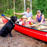
Before setting off for the day of paddling, we took the opportunity to snap a family photo.

Another beach, this one up the West side near Pease Point:


Along the Bagwa Route there are a few reedy places. I think this is probably connecting Bagwa and Lily Lakes:


A couple days later, back at the rail portage on our way home:


Happy but mosquito-bitten:


Tuesday, September 01, 2009

GeoGratis, CanMatrix & CanTopo

While looking to download topo maps today, I realized I was in the wrong set of maps, CanTopo rather than CanMatrix. Wow, CanTopo is pretty cool!

Now, to take a step back. GeoGratis is the website run by Natural Resources Canada where one can download a whole host of maps and stuff geographical in nature. From the GeoGratis web site:
Geospatial data available online at no cost and without restrictions!

GeoGratis is a portal provided by the Earth Sciences Sector (ESS) of Natural Resources Canada (NRCan) which provides geospatial data at no cost and without restrictions via your Web browser.

The data will be useful whether you're a novice who needs a geographic map for a presentation, or an expert who wants to overlay a vector layer of digital data on a classified multiband image, with a digital elevation model as a backdrop.

The geospatial data are grouped in collections and are compatible with the most popular geographic information systems (GIS), with image analysis systems and the graphics applications of editing software.
Most of the stuff there I haven't even a clue what it is (they list 81 different collections), but there are a couple of interest to me including the Atlas of Canada and, especially, the CanMatrix collection.

However, I accidentally clicked on the CanTopo collection rather than CanMatrix. In doing so, I learned something interesting and "discovered" CanTopo:
Abstract
CanTopo is the new generation of topographic maps being produced by NRCan. This digital cartographic product originates from the best available data sources covering the Canadian territory and offers a quality cartographic product in vector and raster format that complies with international geomatics standards. CanTopo is a multi-source product generated from the CDB described in the document Cartographic Data Base: Data Product Specifications. Data within the CDB comes mainly from the GeoBase initiative (www.geobase.ca), NRCan digital topographic data and data from national initiatives. Data from authoritative sources, such as other government agencies both federal and provincial, are identified, stored, and used.

Purpose CanTopo aims to provide digital topographic maps for the Canadian landmass where the demand is the greatest. Output file formats include PDF, GeoPDF, and TIFF. CanTopo digital maps are multipurpose and can be utilized in a multitude of scenarios ranging from emergency response and natural resource management, to geographical education and planning a safe backcountry camping expedition. Plotted versions of CanTopo can also be used along with GPS receivers as an additional aid or digital files can be integrated into some receivers using independent software. As a minimum, all titles published will include new roads, hydrology, metric contours, and updated toponyms and administrative boundaries. Special effort will be made to update “limited access” roads in forested areas. Higher levels of map revisions will be undertaken only with a partnership agreement with other government departments or agencies for specified areas.
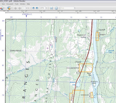
Exciting stuff! Currently, only some areas in southern B.C. are available and I eagerly await them spreading across the country. The maps are downloadable as .tif or .pdf files. I had a look at the maps to see how these new versions compare. See for yourself as I did some screen captures from a map near Hope, B.C. and added them here. The tif files were being viewed in Microsoft Office Picture Manager while the pdf version was viewed in Adobe Acrobat Reader. I tried to view them all so that the zoom level of the map itself was approximately the same for all three. Screenshots were cropped in that heavyweight image editing software, MS Paint, and saved as a bmp file.

There are two sets of CanMatrix maps, the "georeferenced" (?) version and the print-ready version. The latter appears to be cleaned up & straightened compared to the former.

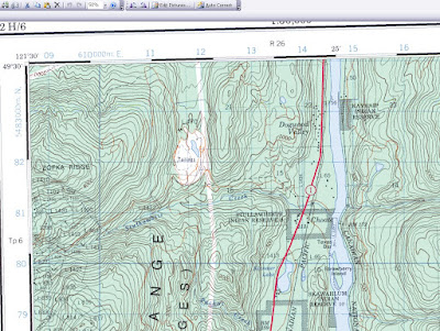
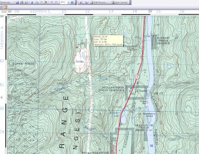
First, here is the CanMatrix (Georeferenced) version for map 092H06. It's essentially a scanned paper map and it seems to typically get a bit crooked in the scanner. (Click the image for a larger version.) The original file size is 78.0 MB.Here is the GeoMatrix, Print Ready version, straightened out and tidied up. The original file size is 41.6 MB.

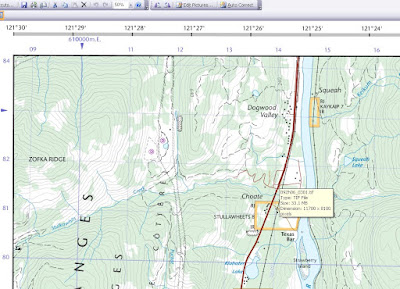
Now here is the CanTopo tif version of the same map. It's much crisper and looks less cluttered although there may even be more information contained in the map. The original file size is 33.1 MB.
Finally, here is the CanTopo pdf version. Note that the pdf version amounts to a much smaller file. The original file size is a measly 4.98 MB, a size that my computer deals with much more readily than the large tifs.


Looking at those maps from the mountains near Hope, B.C., there is perhaps one significant failing of the newer maps - the contour elevations are not as easily interpreted. The CanMatrix versions show the contour elevations for the major contours (see the 4000 contour near Zofka Ridge in the upper left) but the CanTopo versions don't present the information in the same way. Actually, after looking more closely at the full map in regions not pictured, they do seem to offer at least one contour elevation for every hill or mountain allowing you to count and extrapolate the rest of the contours from there. It's omitted from these screenshots because I snipped from the corner of the map. Luckily, this is a matter of only small importance where I typically travel in the wilderness.