Wednesday, September 02, 2009

Family Paddling on Kinsgmere


Our family of four, including daughters aged 3 (nearly 4) and 7, was joined by my wife's cousin and her husband for a recent trip to Prince Albert National Park. PANP is a great place to serve as an introduction to backcountry camping.


After paying our fees at the gate and registering at the office for camping and paying more fees (whew, camping in a National Park is expensive!), we drove to the put-in 30 km from Waskesiu at the Kingsmere River. The Kingsmere River is a lazy and beautiful creek that wanders between high banks and connects Kingsmere Lake with the north end of Waskesiu Lake. The current is moderate to slow, and one can paddle upstream without difficulty. Our fleet included my wife in her 17' cedar-strip kayak, my daughter in her 11' skin-on-frame kayak, Ashley & Ryan (cousin & cousin-in-law) in our 17' fibreglass Clipper Ranger, and me, Kaya the dog, and my younger daughter in our new 17.5' Royalex Swift Yukon with third seat. Although our daughters took turns in the kayak and sometimes paddled on their own, we typically towed them when we had anywhere to go.

We decided to camp at the Southend campsite on Kingsmere, a short paddle and long portage away from the put-in. The portage appears as a roller ramp just 400 m upstream from the boat launch. From the roller ramp, canoes and kayaks were loaded onto the rail carts used to negotiate the 1km long rail portage. There are two types of carts here. There is a small two-wheeled cart that worked well for one person to move one loaded canoe down the portage. There is also a large and very heavy four-wheeled cart capable of carrying a fishing boat and motor across the portage. This larger cart worked reasonably well for me to carry the three remaining boats, stacked one on top of the other with their loads. This large cart, painted green with John Deere stickers, is difficult for one person to push, especially on the uphill sections, however it is easier than portaging all of the boats and gear separately (and with two young kids we had a lot of gear). With two and three people pushing the large load is far less brutal and on downhill sections the trick can be to maintain control (there is a brake but I was pulling instead of pushing the lever).

With the portage out of the way, another 700m or so of river deposit you onto Kingsmere Lake very near the Southend campsite. When travelling through this reedy area, keep your eye open for Blue Herons where the lake meets the river. I have also seen moose along the river (south of the put-in). The southend campsite can handle maybe 7 groups (some large) at once, has a kitchen shelter with a wood stove (which would have been useful in miserable weather), two bear raised bear caches, and two outhouses. You need not paddle to reach Southend as there is a hiking trail that connects with the parking lot at the Kingsmere River put-in. The trail is an offshoot of the Grey Owl Trail and continues on to the nearby warden's cabin. This campsite was our home for 4 nights while we did day-trips in the area. There are also numerous other campsites in the region, along the east shore of the large lake, as well as in the connected smaller lakes of the nearby Bagwa Route.

The south end of Kingsmere Lake near the campground is very shallow and sandy so was a good place for the kids to play in the water and to mess around in the boats. The beach itself is mostly rocky or weedy in this spot, so on one of our days we paddled over to a nearby sandy beach so the kids could play in the sand. Sand is one thing you will find a lot of on Kingsmere Lake, we found it in our tent, in my binoculars, in my coffee, in our sandwiches, in our beer, and more.

Our first full day on Kingsmere was very calm, so we decided to take advantage of it and head out for a paddle on the large lake. We had the destination of Grey Owl's cabin in mind, but knew that everything would have to work out perfectly to achieve that goal and make it back safely. The lake is 11 km long and about 7km wide so it is large enough to get some good waves which tend to pile up on the shallow east side. We brought enough food and stuff with us in case we had to wait out any wind. Travelling with just the two canoes we headed out northward across the lake, more or less following the eastern shore. Our intention was to "play it by ear", only going as far as weather, kids, and our resolve allowed. Making good time despite playing with my new GPS and having to turn around to retrieve poly-pocket hair (a kid's toy) which tragically fell into the lake, we lunched at the Sandy Bay campground where the mosquitoes soon found us. After lunch we continued on to the north end of the lake and began the 3.2 km hike into Grey Owl's cabin, tormented the whole way by the swarms of mosquitoes. It's a nice walk if you can enjoy it. Unfortunately, travelling with the 3-year old and the mosquitoes made this trek somewhat less enjoyable than it could have been. In retrospect, I should have portaged a canoe 600m into Ajawaan Lake and paddled to the cabin (less walking for the kids, fewer mosquitoes). As a side note, this cabin was under threat of being lost to fire earlier in the season when forest fires were encroaching. Since then rain has ensued and hardly a fire has burned in the entire province for some weeks now. At the cabin, we signed the guest book and browsed through, finding the names of friends that have been there earlier in the season. The fair weather continued in our favour and we returned under continued calm conditions. The weather was mostly overcast this day and the obscured sun worked to our favour since it meant we were not fried to a crisp. An interesting aspect of paddling on Kingsmere is the remarkably clear water allowing you to watch the lake bottom while suspended twenty feet above. By the end of the day, we had paddled 25 km and hiked 6.5 km, not bad with kids and novice paddlers along.

Our next day was another gorgeous one, calm and sunny. It was spent playing on the sandy beach, in the water, or reading while drifting in a canoe (away from horseflies and mosquitoes).

On our fourth day we decided to take a tour through the Bagwa Route. Again travelling with only the two canoes, we enjoyed calm weather on Kingsmere Lake. After lunch and an hour or so relaxing and playing on a beach near Pease Point, we round the point to face head winds out of the southwest. Those winds made us work a little harder through the channel and gave us some waves to deal with on Bagwa Lake. We have seen moose before in the weedy channel to Bagwa Lake and our hopes were high for seeing the large mammals but we were not so lucky. We did see pelicans on Lily Lake. The wind blew us down the small lakes of Lily & Claire. The portages between those lakes are very swampy at their ends (as has been the case for many years) and especially the Claire Lake end of the Claire-Kingsmere portage. Portaging with small kids can be no fun, especially when the mosquitoes are horrendous. Once back onto Kingsmere Lake, the wind had diminished again (we were in the lee, but the wind had really dropped away) and our short paddle back to the Southend campsite was very beautiful. All told, it was a 20km day with two portages.

Our fifth day was yet another gorgeous weather and the temperature had climbed to the mid-twenties. We packed up and made our way back to the put-in (with the girls fighting over whose turn it was to paddle the kid's kayak). After lunch and ice-cream in Waskesiu and playing at the beach-front playground, we headed out on the highway and made our way home after nearly two weeks away.

Prince Albert National Park provides a family-friendly and novice-friendly camping experience. You are never far from help (with the exception of the Bladebone Canoe Route). Wind and waves can be a serious issue that paddlers need to be aware of and prepared for, but there are routes that can minimize this. We were lucky to have the weather we did. Despite that we did not see any large wildlife, the opportunity to see moose and other animals is greater in PANP than most areas I paddle (where moose represent many meals so are hunted by the natives for food). Except for their muddy ends, the portage trails are generally in good shape and well maintained. There is much to see and do, and there are some destinations of historical interest (Grey Owl's Cabin). Although we opted to head to Kingsmere this time out, we have also gone to Crean Kitchen campsite on Crean Lake. The Crean Kitchen campground is smaller than Southend but provides similar amenities including a shelter with wood stove. Crean Lake is larger and more open to wind than Kingsmere so can be a difficult place for open canoes, but the Hanging Heart Lakes should provide no difficulty for most. Sand is even more abundant on Crean than at Kingsmere. Canoes & kayaks can be rented in PANP from the Waskesiu marina or the Hanging Heart Lakes Marina.

And now for the pictures. 
(I've been having trouble with the pictures disappearing, just in case they do, here is a link to the Picasa Album where they are supposed to be stored.)

Kingsmere 09

Here we are ready to launch into the Kingsmere River:


My daughter paddled her own kayak.


Four hundred metres later we arrive at the roller-ramp which raises the boats enough to allow them to easily slide onto the portage carts.


 A bridge spans the river here connecting the portage trail with the trail to the parking lot (to the South) and Grey Owl's cabin (to the North).


This sign was posted near the portage:


Later that evening we were treated to a very nice sunset at the Southend campsite.


During our paddle to Grey Owl's cabin the girls played in the canoe, making use of the centre seat. When unloaded, the kids used that seat as a table more often than as a seat.


Lunch on a beach up the East side of Kingsmere Lake:


Once at the North end of the lake, we set off on the 3.2km trail to Grey Owl's cabin:


In this photo you can see the sprinkler and hose atop the cabin which were used (or were ready to be used) in June to prevent the cabin from burning in forest fires which threatened the area.


Grey Owl (Archie Belaney) & Annahaero's graves are also here, atop the nearby hill.

Signing the guest book:


Yours truly on the return across Kingsmere Lake:


Did I mentioned we had fair weather? We were very lucky, the wind can come up on short notice and paddlers must be prepared to deal with it. Don't get caught a very long way from shore unawares, especially with kids along.


Back at camp, we were joined by some good friends who we had wanted to trip with for a while now. We are not put off by their 2-dimensional personalities.


Playing in the shallow, clear & warm water at our campsite:


Playing ball is a bit of an unusual activity for us when paddling, but this campsite with a large open area can accommodate it.


While the kids played ball, I mixed up some Caesars.


Before setting off for the day of paddling, we took the opportunity to snap a family photo.

Another beach, this one up the West side near Pease Point:


Along the Bagwa Route there are a few reedy places. I think this is probably connecting Bagwa and Lily Lakes:


A couple days later, back at the rail portage on our way home:


Happy but mosquito-bitten:


Tuesday, September 01, 2009

GeoGratis, CanMatrix & CanTopo

While looking to download topo maps today, I realized I was in the wrong set of maps, CanTopo rather than CanMatrix. Wow, CanTopo is pretty cool!

Now, to take a step back. GeoGratis is the website run by Natural Resources Canada where one can download a whole host of maps and stuff geographical in nature. From the GeoGratis web site:
Geospatial data available online at no cost and without restrictions!

GeoGratis is a portal provided by the Earth Sciences Sector (ESS) of Natural Resources Canada (NRCan) which provides geospatial data at no cost and without restrictions via your Web browser.

The data will be useful whether you're a novice who needs a geographic map for a presentation, or an expert who wants to overlay a vector layer of digital data on a classified multiband image, with a digital elevation model as a backdrop.

The geospatial data are grouped in collections and are compatible with the most popular geographic information systems (GIS), with image analysis systems and the graphics applications of editing software.
Most of the stuff there I haven't even a clue what it is (they list 81 different collections), but there are a couple of interest to me including the Atlas of Canada and, especially, the CanMatrix collection.

However, I accidentally clicked on the CanTopo collection rather than CanMatrix. In doing so, I learned something interesting and "discovered" CanTopo:
Abstract
CanTopo is the new generation of topographic maps being produced by NRCan. This digital cartographic product originates from the best available data sources covering the Canadian territory and offers a quality cartographic product in vector and raster format that complies with international geomatics standards. CanTopo is a multi-source product generated from the CDB described in the document Cartographic Data Base: Data Product Specifications. Data within the CDB comes mainly from the GeoBase initiative (www.geobase.ca), NRCan digital topographic data and data from national initiatives. Data from authoritative sources, such as other government agencies both federal and provincial, are identified, stored, and used.

Purpose CanTopo aims to provide digital topographic maps for the Canadian landmass where the demand is the greatest. Output file formats include PDF, GeoPDF, and TIFF. CanTopo digital maps are multipurpose and can be utilized in a multitude of scenarios ranging from emergency response and natural resource management, to geographical education and planning a safe backcountry camping expedition. Plotted versions of CanTopo can also be used along with GPS receivers as an additional aid or digital files can be integrated into some receivers using independent software. As a minimum, all titles published will include new roads, hydrology, metric contours, and updated toponyms and administrative boundaries. Special effort will be made to update “limited access” roads in forested areas. Higher levels of map revisions will be undertaken only with a partnership agreement with other government departments or agencies for specified areas.
Exciting stuff! Currently, only some areas in southern B.C. are available and I eagerly await them spreading across the country. The maps are downloadable as .tif or .pdf files. I had a look at the maps to see how these new versions compare. See for yourself as I did some screen captures from a map near Hope, B.C. and added them here. The tif files were being viewed in Microsoft Office Picture Manager while the pdf version was viewed in Adobe Acrobat Reader. I tried to view them all so that the zoom level of the map itself was approximately the same for all three. Screenshots were cropped in that heavyweight image editing software, MS Paint, and saved as a bmp file.

There are two sets of CanMatrix maps, the "georeferenced" (?) version and the print-ready version. The latter appears to be cleaned up & straightened compared to the former.

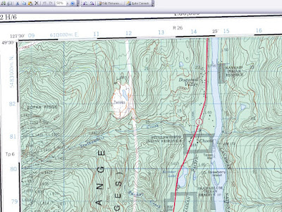
First, here is the CanMatrix (Georeferenced) version for map 092H06. It's essentially a scanned paper map and it seems to typically get a bit crooked in the scanner. (Click the image for a larger version.) The original file size is 78.0 MB.Here is the GeoMatrix, Print Ready version, straightened out and tidied up. The original file size is 41.6 MB.

Now here is the CanTopo tif version of the same map. It's much crisper and looks less cluttered although there may even be more information contained in the map. The original file size is 33.1 MB.
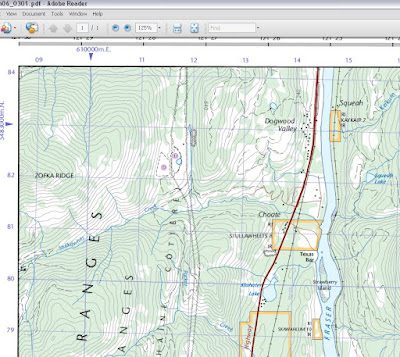
Finally, here is the CanTopo pdf version. Note that the pdf version amounts to a much smaller file. The original file size is a measly 4.98 MB, a size that my computer deals with much more readily than the large tifs.


Looking at those maps from the mountains near Hope, B.C., there is perhaps one significant failing of the newer maps - the contour elevations are not as easily interpreted. The CanMatrix versions show the contour elevations for the major contours (see the 4000 contour near Zofka Ridge in the upper left) but the CanTopo versions don't present the information in the same way. Actually, after looking more closely at the full map in regions not pictured, they do seem to offer at least one contour elevation for every hill or mountain allowing you to count and extrapolate the rest of the contours from there. It's omitted from these screenshots because I snipped from the corner of the map. Luckily, this is a matter of only small importance where I typically travel in the wilderness.

Thursday, August 27, 2009

Montreal River in August

Last Friday a group of us paddled the Montreal River from the Highway 2 bridge to the gravel road 165 bridge, a distance of about 40km. It is apparently very unusual to be able to paddle the Montreal at this time of year, with May-June being the usual window of opportunity. Today I talked to Martin at the Saskatchewan Watershed Authority to find out what the water levels were at and what they might be expected to do over the coming couple of weeks. Martin informed me that the river was running at about 25 m3/second, a level that is higher than the average spring peak (the median actually). He also suggested that because of the large size of Montreal Lake which feeds the river, the river should be runnable for some time to come yet.

Martin also sent me this graph of the flow for 2009 at the outflow from Bigstone Lake:


An interesting note was that the water metering station is now a "real-time" station and no longer requires manual reads. The station is expected to soon be added to the list of stations that are available to the public online!

So, if you want to run the Montreal River but missed you chance in the spring, now is the time. The Montreal River has lots of Class 1+ rapids and at the levels we paddled it was not at all technical (I ate a can of salmon while negotiating a series of rapids), but it was a lot of fun, especially the last third which had a couple of stretches of C1/C1+ water that were 3-4km long.

For information on running the Montreal, see Laurel Archer's book Northern Saskatchewan Canoe Trips. I also found a brief description and map online at http://www.princealberttourism.com/index.php?option=com_docman&task=doc_details&gid=129&Itemid=86 (down at the bottom click "download" or "view" to see some information on running the Montreal as a day-trip).

Follow Up: I posted some pictures as their own post. You can find them at http://pawistik.blogspot.com/2009/11/montreal-river-follow-up.html.

Monday, August 10, 2009

Chance Meeting

Last week in the office at Prince Albert National Park while booking in for camping on Kingsmere Lake, I met a fellow boat builder that is currently building a Redfish Spring Run. This fellow was also at the boatbuilding workshop hosted a couple of years ago by Kisseynew Canoe Company. If you happen to be the guy I was chatting with, could you please contact me? I'd love to chat some more and check out your current build.

By the way, we had the guillemot & the kid's kayak out for that trip (actually my entire fleet of 4 boats was used on that trip). We camped at Southend for 4 nights and took day tours up to Grey Owl's cabin, the Bagwa Route, and just to play on the beach. I'll try to post specifically about this trip and the one immediately before on the Churchill River.

Thursday, July 30, 2009

Highwater

Sask Watershed Authority's version of the current streamflow graph for the metering station above Otter Rapids:
Here is the Environment Canada version showing the levels for the last 13 months or so:

Should be fun!

Wednesday, June 24, 2009

Ice-Out!

Yay, the ice is off of Cree Lake & our plane can land! The above satellite image is from June 21st, the most recent date where the area wasn't completely obscured by cloud. Cree Lake is in the upper right quarter of the image just north of the wispy clouds and the water is coloured black. Wollaston Lake to the NE on the edge of the image is still covered in ice, visible as light blue. Did I mention the image is from June 21st! If you look at the large version of the image, you can see a forest fire burning on the eastern side of Cree Lake, what must be very close to MacIntyre Lake Lodge. By scrolling back through the satellite images, I was able to determine that the ice went off of Cree Lake during the few days up to June 15th.

These images are from the MODIS Rapid Response System - http://rapidfire.sci.gsfc.nasa.gov/
To quote from the web site:
The MODIS Rapid Response System was developed to provide daily satellite images of the Earth's landmasses in near real time. True-color, photo-like imagery and false-color imagery are available within a few hours of being collected, making the system a valuable resource for organizations like the U.S. Forest Service and the international fire monitoring community, who use the images to track fires; the United States Department of Agriculture Foreign Agricultural Service, who monitors crops and growing conditions; and the United States Environmental Protection Agency and the United States Air Force Weather Agency, who track dust and ash in the atmosphere.
It's pretty cool stuff actually. As long as the clouds aren't in the way, I can see where fires are burning and what the ice conditions are like. The clouds that have obscured things the last few days have carried rain that has put out the fires in the area (including one that stopped 30m from a colleague's research site near Key Lake!). Here's an edited version of a fire map available from the site from the period of 06/10/09 - 06/19/09:
Thankfully, it shows no fires in the region North of Cree Lake where we'll be.

Four days from now I'll be on Cree Lake about to head down the Cree River. Late ice-out should mean that the Lake Trout are in shallow waters and hopefully they are hungry! After we spend half a day or so on the lake, then we'll be off downriver and into the territory of Grayling, Pike and a few Walleye (this river is not a major walleye destination, but there are couple of good spots reported).

Sunday, June 21, 2009

Light & Sound

Tonight I celebrated the summer solstice and the earliest portion of Father's Day with a midnight paddle. My wife was supposed to join me for a paddle a bit earlier, but she never returned from going to lay down with the kids to help them sleep. Ready for bed myself, I decided to take the opportunity for a quiet late night paddle on the longest day of the year. As I paddled, many thoughts went through my head & I want to record a few of those impressions before I head off to bed at last.

A launch under the glaring marina lights, I paddle through a crowded parking lot of boats to the sound of a wedding dance at the golf clubhouse.

Escaping the noise, lights and protection, I emerge onto a lake lit by a northern twilight glow.

Here and there, cabin lights dot the far shoreline.

There is a breeze creating a light chop which noisily slaps the near-empty hull of my heeled-over canoe. I head upwind, northwestward toward the sun that is journeying below the horizon.

As I round a point and paddle along the shore, I learn to listen for the sound of waves slapping rocks just above the surface.

I catch a fleeting glimpse of a light, a firefly perhaps. But I see only a flash and I decide it is likely only a light from a cabin shining briefly through the trees, or perhaps a reflection.

Having come as far as I wish, I stop to drift, listening to the sounds of the waves hitting shore.

Gazing skyward, I take in scene above. Away from the bright marina lights, the northern sky glows and there is plenty of light to paddle by, despite there being no moon. The stars are brilliant points of light, yet only the brightest are visible on this short night.

As I turn to face the east and my return, I notice flashes of lightning many miles in the distance, much too distant to be heard.

Paddling downwind the waves quieten and all sense of speed is lost as I pass farther from shore.

Close again to shore, I see short bursts of light flitting above the rocks. The fireflies are indeed out tonight and I consider myself lucky to see them. The cool brilliant light of the beetles is in sharp contrast to the far off flashes of lightning.

The steady call of frogs is prominent whenever the shoreline is sheltered from the now diminishing waves.

As I approach the marina, the obnoxiously bright lights begin to pierce the trees, finding & blinding me. To the sound of Jumping Jack Flash pumping from the banquet hall, I give the marina a pass.

The sound of reeds brushing the hull tells me I am in a shallow and protected bay. Briefly, I am aware of the strong smell of mint mixed with poplar.

A dark break in the shoreline of the bay suggests the mouth of a creek. I cannot breach the entrance, and the late hour forces me to return to the glare and noise of the marina.

With a canoe overhead, the squelch of a sandal in the mud reveals a puddle in the shadows.

The car lights illuminate three scattering killdeer chicks in the parking lot, explaining the distracting cries of the parents heard earlier.

Back in the dimly lit cabin, I am glad I was able to draw myself away from the enjoyable sounds of Saturday Night Blues on the am radio. It was a beautiful night to be on the water.

Thursday, June 04, 2009

The Mobies Are Coming! The Mobies Are Coming!

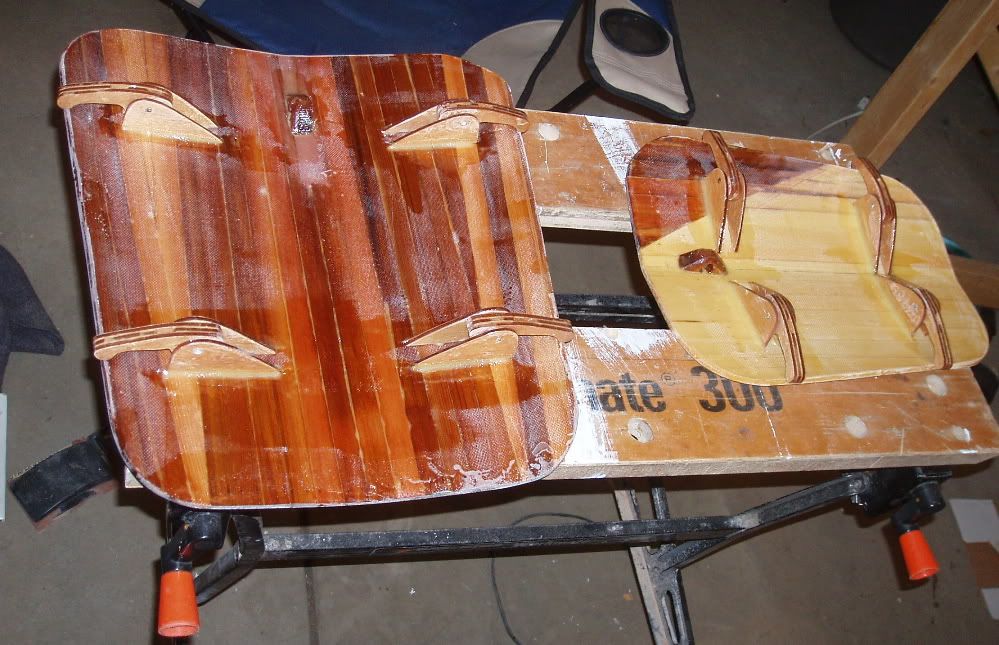
So, "what's a moby" you might ask. A moby (plural, mobies) is a hidden latch mechanism for the purpose of keeping the hatch of a kayak closed. The moby, is a lever attached to the underside of the hatch cover that under the tension of bungie cords presses against the underside of the kayak deck and holds the hatch securely closed. I added mobies to the kayak when I built the kayak 2 years ago, but I built them using 1/8" recycled mahogany plywood. That proved too weak and 2 of 8 of them have broken. So, I am rebuilding the mobies. This time I have made them much beefier. They are being constructed of 1/4" poplar wood, with the grain in the direction of required strength. The poplar was reinforced before cutting out the pieces by adding a layer of fiberglass on each side. They are also larger in every dimension than the older version, which will make them stronger again.

This post was just intended to be a quick update. I have been taking pictures along the way in preparation for a future comprehensive Moby post, perhaps a "how to". So far, I have fiberglass-reinforced 1/4" poplar, drawn a new and enlarged moby template, cut out all the pieces, and cut off the old mobies and cleaned up the hatch lids. This evening, I glued the mobie components together with thickened epoxy and added another layer of glass to the underside of the hatch lids.

In the meantime, here are a couple of pictures from when I made the Mobies, Mark I.

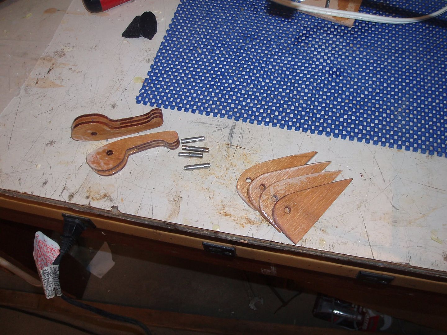
Partially assembled pieces.
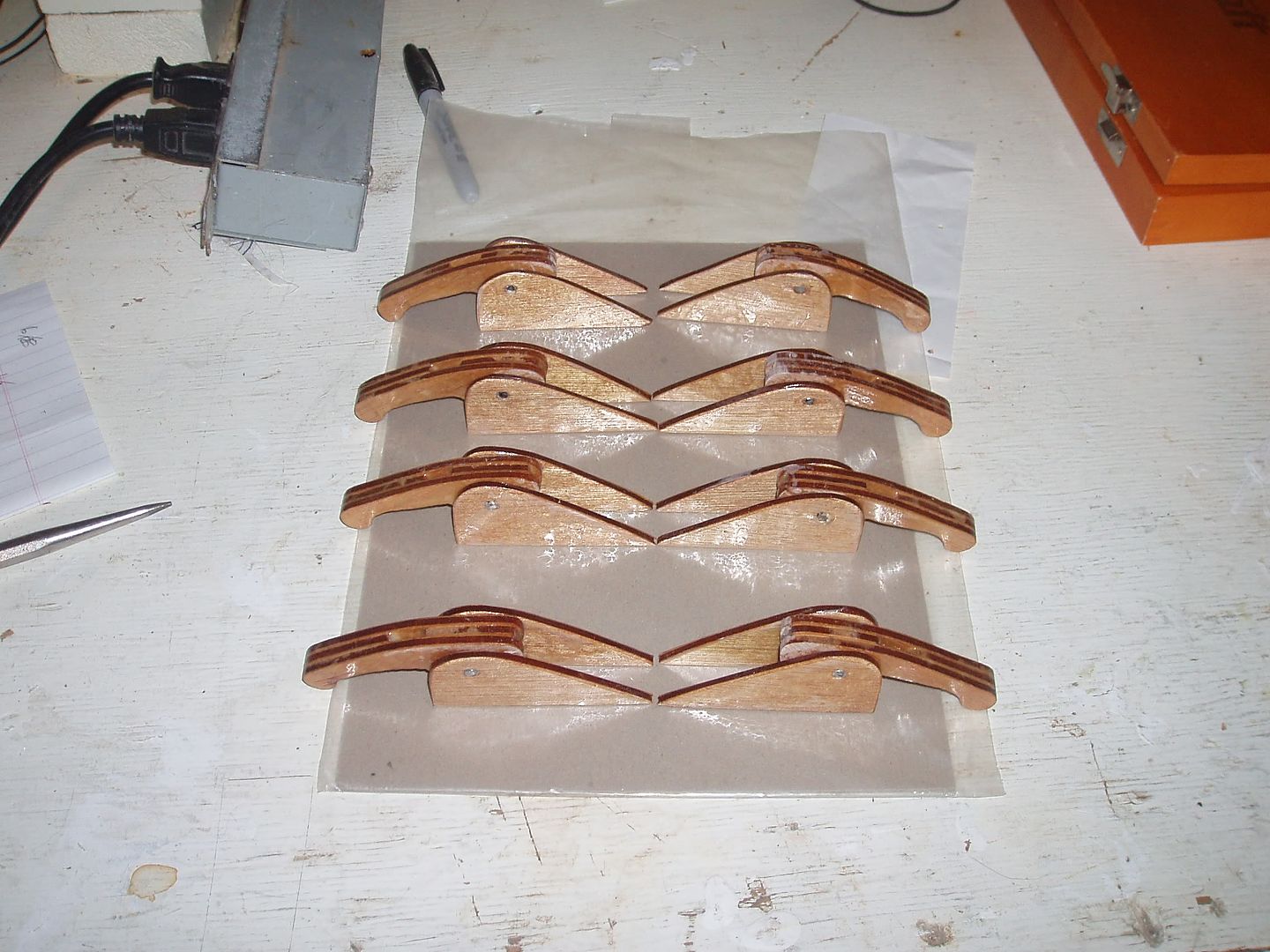
A pod of mobies ready for installation.
Mobies on hatches.

Monday, May 04, 2009

I know that plane!

Came across this blog post today, about an Otter airplane operated by Osprey Wings in Missinipe. I've flown in this Otter on the way in to the Paull River a few years ago. I find it interesting to learn the long history of a plane I've flown in. This summer I'll again be flying in a Turbo-Otter to the Cree River, though I'm not sure if it'll be the same one.

Tuesday, April 28, 2009

Open House Time Again

It's time once again for the Saskatoon Canoe Club's annual Open House at the Boathouse. This coming Sunday, May 3rd, from 12:00 to 4:00 pm we will be hosting an open house and barbecue in Victoria Park along the river near the docks. Come and see what membership in the Saskatoon Canoe Club can bring to you and your family. Whether you are interested in quiet paddles down the river, marathon racing, kayaking, solo trekking, improving your skill level, or just want to have fun on the water… our club may be the one for you. Meet a few club members and our sponsors. See what we have to offer on May 3rd at the boathouse along the river in Victoria park near Riversdale.

That, more or less, is the blurb that has gone out to various local media announcing our upcoming open house. This is usually a pretty busy day for us and fair weather will likely mean we have hundreds of people visit our boathouse bay. At least I hope so, since I'll be picking up 200 hamburgers on Friday. By the way, we'll only be serving burgers until they're gone so don't show up at 3:45 and be disappointed if we can't feed you!

Thursday, April 23, 2009

World Book Day

It was World Book Day today apparently, so it seems like a good time to update the "What I'm Reading" feature.

Building Strip-Planked Boats, Nick Schade. Another boatbuilding book has been added to my library. This just-released book was written by the author of The Strip-Built Sea Kayak, the host of the Kayak Building Bulletin Board, and the designer of the Guillemot kayak I built. To be honest, I haven't really started to read this one, though it is on my nightstand and I have paged through it (and this is supposed to be a somewhat boatbuilding-related blog). It looks good so far. It's about twice as thick as his earlier book, which I used to guide me through the Guillemot build. The photos and illustrations are all black & white. I look forward to see which techniques he has updated from the earlier book, published about 15 years ago. I have noticed that he uses a different style of stems, which is a good improvement. The new book covers the building of a very sexy looking kayak, the small "wee lassie" canoe, and a dinghy. After I have actually read through it, I'll try to post some comments.

The Russlander, Sandra Birdsell. This book tells the story of a Russian Mennonite girl in the early 20th century. Katya is living through turbulent times, and there is tension growing between the wealthy Mennonite farmers and the Russian peasants. Currently, I'm about halfway through. The book occasionally makes reference to Katya as an elderly woman in Winnipeg and it appears that the story is her recollections. It's an interesting book so far.

The Unicorn's Secret: True Heart, Kathleen Duey. I've been reading this series of books with my 6-year old as bedtime reading for the past several months. Picked from the library as a chapter book that looked simple enough for her to understand, and featuring unicorns it was sure to have her interest. I am really enjoying the time spent with my daughter reading these books. This evening we finished the 6th book in the series and my daughter is eagerly anticipating the final two books.
The Egg In The Hole Book, Richard Scarry
. I also read with my younger daughter today, and this is one of those we read. I asked her what she likes about this book and she said "the egg".